Foiled again by the Aiptek MegaCam (as in some weird Japanese monster movie)…
Photos won’t open up, so I’m forced to write prose.
As it turned out, the inaccessible still photo issue got solved, but as
I had started hand-writing notes, I forced myself to finish the tale.
This wasn’t really some super-epic ride with terrifying conditions to
overcome. It was just a great day spent riding and spending time
with enjoyable company, the kind of ride that too-often, we take for
granted. So, maybe that’s why I kept writing - just to help fix it in
my memory a little better for some future day.
–
September 4, 2006 - Labor Day Ride
Most of us ended up doing non-riding things on Sunday, so email plans
were hatched for a Labor Day ride over mixed-terrain. Carlos was
ready for anything, I was thinking about trying to talk folk into
ascending Tenderfoot, and JimG had coaxed Stork into joining our gang.
Someone with a clean bicycle was already waiting at the meeting spot
when I rolled up, and much to my amazement, it was Carlos. It was
not amazing that he was there, but it was startling and mildly
disturbing to see his bicycle so clean. Because of the regs where he
lives, the only spot where he can clean off his bicycle is actually the
bathtub. I’m sure that’s more a loophole than the original intent of
the rule.
He had received a system-terminated call from JimG, who was herding
Stork our way. They rolled up before too long and we opted for
the easier initial climbing - up Railroad Grade via downtown Mill
Valley.
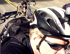
Before we left, I got to model the camera helmet-mount I cobbled
together for the Aiptek SD. Despite a blog post stating how I was
going to put the damned thing down for a while, I came across a
headlight mount that I used on my VistaLite system. With a slight bit
of padding and a few bits of hook & loop straps, it seemed to work
correctly, and an around-the-house test suggested that the angle was
more or less correct. So, there I was with a small digital camera
strapped to my helmet, pretty much insuring the drowning of whatever
shreds of dignity lay floating in my wake.
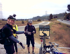
Plus, it did seem to be one of the simplest ways to damp the trail vibration.
We set off, skirted the lazy morning traffic and rolled up the initial
parts of Railroad Grade, doffed a layer at the first big turn and
rolled onward again. A few other riders appeared with the increasing
sunlight, as we started to find the edges of the San Francisco fog
layer near the top of first part of trail. Trail is probably
being generous as it’s mostly wider than many of the neighborhood
roads. This was the railbed for the tracks which climbed to the
top of this mountain in the early 1900’s. The immediate benefit
to riders and hikers is that it never really gets any more difficult
than about 6 percent grade. But, it isn’t really a narrow ribbon in the
wilderness.
Despite all of this, it’s actually a trail I really like riding - the
history of it, the sheer turn-of-the-century “can-do” nature of it, the
knowledge that even with its extreme accessability, few of the
residents of Marin County will ever visit its length - all this and
more contribute to my enjoyment of it.
JimG, however, is not currently contributing to my enjoyment of it. Now
on the “upper” part of the dirt section after a brief connector on
Summit Ave, he’s clearly starting to feel pretty peppy on his new light
wheelset. His snappy pedal strokes cause him to edge out in
front, and some dumb canine sector of my brain triggers the chase
response. He opens the throttle a bit more and I try to limit my
losses. This repeats until we’re streaking along over rock and trail,
passing sensible folks on fully suspended mountain bikes until we hit a
fork in the road and I garble something about making sure Stork knows
which trail to take here.
Luckily, this causes him to stop, where we both blame the other for “starting it…”
As we adjust layers and gear, a woman rolls up past us. We had seen her
at the transition from pavement to dirt, and we realize that she’s
riding a Surly Long Haul Trucker, rigged with what look like 26″
wheels. JimG reminds us that the smaller sized frames use this
wheelsize.
We get going again and Carlos just motors away from us. I find a
pace that finally manages to keep him within sight and we all recollect
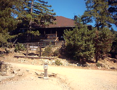
at the West Point Inn - named as this was the western-most point on the
railroad bed. In the old days, you could take a stage down to
“Willow Camp” - now known as Stinson Beach. I use the facilities,
threading my way through a backpack group and those people who had
stayed there the previous night and were now doing cleanup
chores. We debate sunscreen, tires, old relations, the fact that
JimG didn’t wear his “lucky” jersey, and Carlos tells us about a game
played in Columbia with black powder, heavy rocks and beer.
Explosives and alcohol. Hmmm….
As we are unlikely to find either nearby, we remount and squeeze out
the upper section of Railroad Grade. Just before we hit the
pavement of East Ridgecrest, we pass the Surly LHT woman, who has found
a prime spot of shade and is enjoying a good-looking sandwich. This
helps to refocus our resolve, as we wave and make good time to the
picnic tables near the East Peak parking lot.
Though Stork had been hurting at the beginning from unspecified causes,
he seemed to feel a bit better after his Safeway deli sandwich that we
enjoyed at the picnic table near the East Peak parking lot atop Mt
Tamalpais.
After lunch and wrangling everyone’s leave-clock to synchronization, we
dropped off the East Peak and … climbed? Yep - it’s the
odd thing about Mt Tam. Though you are on the (currently) highest
portion of the mountain, the first thing that you hit is a couple of
upward pitches. They aren’t supremely difficult, but it always
seems hit a bit harder than they look. Combine that with a couple
handfulls of food loaded into your midesection, as well as 30 minutes
of sitting around and the legs just squawk with unhappiness.
But, by the time you can see the “golf balls” on the West Peak, the
paved descent awaits. I click on the video camera, JimG does the same
and we string out through the mild curves. Without any crazy-fast
behaviors, we soon bring the most recent auto into our sights.
Luckily the trailhead of Rock Spings/Lagunitas Fire Road appears before
we become too spectre-like in their rear view mirror. I pull a handfull
of brake and slip off via a narrow shortcut at the
“close-off-the-mountain” gate, while Carlos and JimG backtrack through
the main gated entrance.
The descent invigorated us, and JimG charges forth onto the abrupt
pitch which starts the trail. He goes for the small chainring,
and immediately ceases forward motion. Carlos and I roll up to find his
chain well wedged between his middle and small rings. With the triple
crankset he’s using, there’s enough of a gap for the chain to slip
behind the small ring. Luckily, he had eased off on the pedaling, and
we combine four or six hands and untangle the chain. No visible damage.
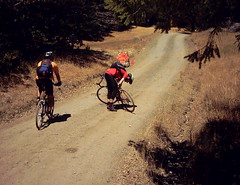
Carlos leads us up the rest of this first bit, and we stay pretty well
together. It’s another round of climbing/suffering after a
static-legged descent. We ride past heavy equipment on the side of the
fire road, and I realize that the surface is much smoother than it was
back when JimG & I rode this trail in the beginning of July.
It’s also California trail-powder loose, and both JimG and I find that
our CX tire nibblies (well, they h’ain’t “knobs”…) manage to unhook a
few times, sending up clouds of dust. Even Carlos’ tire slips a couple
times, a noteworthy event. And he rides smooth treads.
I try to hold onto his wheel up the next incline, which could be
described as “tricky”. Not really technical, but steep and a bit
pitchy, with some strange cambers and usually a plethora of
softball-sized rocks. The rocks are curiously absent now, so it’s
more a matter of weight distribution and dogged determination. At least
that’s the sample I keep replaying while climbing.
We recollect above the Portrero Meadows, ready to enjoy what will be a
steady downhill to Lake Lagunitas. It’s clear that they’ve been
grading this trail - they do that before the winter rains hit, so that
the fire roads stabilize with the rains. This means two things
for us: (1) lots of loose, loose dust and dirt and (2) rocks and
potholes thoroughly obscured by this loose layer.
If you are running big meaty tires and sitting on a hinged frame with
lotsa movement, it doesn’t matter too much. Sure, you can get
yourself into a whole heap of trouble on any bicycle. But, this
specific type of trail condition can be addressed in that manner.
Riding a skinny tired bike on the trail, as I’ve written, is a lot more
like light tackle fishing - you just cannot force things or it stops
working altogether.
Pretty soon after you decide that riding a cross bike on trails is a
good idea, you really get used to what could be termed a “lack of
control.” You slip, slide, graze rocks and bumps and soemtimes find
yourself moving in quite a different direction than the bicycle is
pointed. But, there is a speed where it all works, and you kind of skip
across the surface of things, much like a rock across a pond. Your
momentum tends to keep you going the right direction, and as long as
you can periodically “touch down” for corrections, it works pretty well.
(I think it’s really the same thing that you do when riding off road
without any type of suspension on a mountain bike - the narrow tires
and drop-bar position on a CX bike just minimize the margin of error.)
All of which is reasonably academic and after-the-fact. The
reality was that we were coming down on what looked like wide smooth
trails, and in many places it got downright wacky. The grading made
things easier on the climbing, but significantly sketchier on the
descents - you can get sideways and crossed up in a big hurry (as the
boys and girls on Repack found back in the day.)
Have no doubt - the last part of the trail that drops to Lake Lagunitas
is pretty steep. You feel like a small plane that has to lose a
few thousand feet quickly in order to land at some rustic airport.
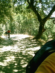
By this time, we’d all spread out a bit. Carlos had gone ahead, while I
waited to make sure both JimG and Stork collected and directed
themselves the right way at the last trail option. After swinging
through numerous banked turns and steep straight bits, the cool blue
reflection of Lake Lagunitas was a welcome sight. Carlos had been
waiting there, snapping a few photos. I joined him, stretching
regaining my breath as we awaited the other half of our group.
Carlos and I chatted a bit about the stretch of trail - as it is part
of the proposed “Mixed-Terrain Populaire” route for the SF Randonneurs.
Depending upon the weather conditions at the time, it could be pretty
interesting, especially for riders who had little offroad experience.
It actually could be a bit of a shock.
The time stretched a bit long, and even as I joke about it, the idea
that we might need to backtrack up the steep hill began forming.
Just about then, they appeared around the bend. Unfortunately,
they were walking.
My first guess was that Stork’s slightly rattly headset had worked
itself loose. As it turned out, JimG had done a soils test with
his elbow on the final drop. His tire found something hidden in
the dust and made him intimate friends with the topography.
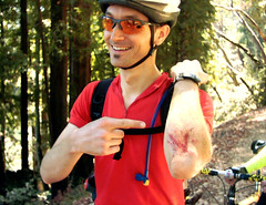
He showed off the abrasion for the camera, and though it was pretty
dirt-encrusted, no flaps of skin hung off of it and the bleeding was
reasonably controlled. We would not be forced to find a Med-Evac
route. Instead, we rolled easily forward to one of the lake’s
feeder streams, in the shade among the redwood trees, and sat on some
log-hewn trail barriers below the bridge.
As dogs and people collected and passed by, the three of us with intact
dermal layers goaded JimG into using the alcohol swab for cleaning. He
did. It clearly hurt, but the blood lost it’s ochre hue and
returned to a nice crisp red, which received antibiotic ointment and an
impressively large band-aid.
JimG also figured out that somewhere along the line, he had tripped the
combination of buttons on the Aiptek SD that caused his images to be
erased.
Once again rolling, we eased up the rise on Lakeview and down Eldrige
Grade towards Phoenix Lake. My helmet-cam started making new
beep-sounds, so I dropped back to see what was up. It no longer
was letting me take any video footage - “beep”ing to a stop
immediately. Maybe the batteries? Those were fully charged
the night before. Maybe the heat of sitting in direct sun atop my
helmet? Who knows. There warn’t gonna be none of that vidyo-ing by me
anymore.
Caught up with the boys at a wide spot in the trail, and we rolled past
another group, topped off at the locals-only drinking fountain and then
scooted down the last twisting bits of Eldridge Grade. We’d been
encouraging Stork with the fact that the ride was now “mostly
downhill”. Of course, “mostly downhill” can be equated to “some
climbing left”, which is what we encountered on the incline up Shaver
Grade to Five Corners.
As Carlos and I creaked up the last parts of the climb, we came across
the hardest working man on the trails today - a fellow working his way
up the same trail with an Alley-Cat attached to his bike. His young
daughter sat back there, looking up at the birds, back at daddy and all
around - not pedaling one whit. I tried to say something reasonably
encouraging, but all I could see was the whites of his eyes and several
large veins sticking out in his forehead and neck.
He caught up with us as we waited for JimG and Stork, breathed hard for
a while and asked if we heard the squeaking. I allowed as how it might
have been my bicycle, and then tried to talk his daughter out of her
string cheese. No luck there, so we zipped out Concrete Pipe road
to Bolinas-Fairfax and dropped into town. By the time I made sure
Stork was on course, avoided getting wedged between some tourist in a
convertible and a parked car, and picked up the waiting JimG, Carlos
had scooted ahead to our destination - the Java Hut.
Maple Scones, Seriously Frostinged Twisty Things, Fruit Scones and
strong coffees distributed to all hands. Double rations to keep
the crew happy. It worked, and we went from mildly aching and
calorically depleted to happy, humming, wanta-try-my-bicycle buddies
once again. In perfect weather, we eased southward along the Fairfax –> SF
“commute route.”
Though normally I leave the gang in San Anselmo, I tagged along down
into Larkspur. We chatted and spun along, getting narrow when a
car needed to pass. The post-hard-stuff bliss spread out through
everyone, I think, and it was just one of those nice rides towards the
end of summer you don’t want to end.
But, did actually need to get back, and 41 miles showed on Carlos’ bike
computer when I peeled off and tacked back into the winds that
separated me from home. They still had to hop over Camino Alto and
climb to the bridge, so I sorta felt like I was cheating a bit…
Ride Head Tune:
Everclear - “Santa Monica”
Links to related items:
My video Page for this ride
My Photos
Geo-Tagged Ride Photos
JimG’s Photos
JimG’s Video
JimG’s Ride Description
Carlos D’s Photos